First leg of this trip is to Westport (101 km). This is a lovely day of winding, generally coastal road that rises
and falls in a series of short, low hills. Be sure to take in the Punakaiki Rocks, a spectacular series of
coastal rock formations where the rough sea surges and ebbs in a series of cauldrons and blowholes. There are a
small number of sharp hills rising to 200 metres at Pakihi Hill, but you can take a break at Charleston (75 km,
backpacker, store, camping), or head over the last hump of highway and cycle downhill the last ten kilometres
into Westport.
Be careful on this road. It winds and is narrow in parts and bus drivers in particular are often impatient.
Westport is a fair sized town with all the facilities you generally require, camping grounds, supermarket,
backpackers, bike shop, pubs and cafés. Westport to Karamea (97 km) is flat apart from a steepish 400 metre
climb over the Karamea Bluff and a short climb over the Happy Valley Saddle. This is a quite beautiful ride and
there are a number of small towns en route where you can take a break. Granity (30 km, pub and store), or Little
Wanganui (78 km, pub, backpackers).
Karamea is a small township with pub, backpackers, store and camping. It is most notable for being at the end of
the famous Heaphy Track, one of New Zealand's best known walking tracks. Karamea is, of course a dead end and
you will have to turn round and head back to Westport, or catch a shuttle bus. You cannot cross the Heaphy Track
unfortunately.
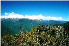
This is a pleasant day's cycle where the road rises gradually, but not noticeably, to around 300 metres. To
avoid traffic, take the lighter route on the northern side of the Grey River and visit the old coal mining towns
in the district.
There is a lot of New Zealand pioneer history here from mining disasters at Brunner to attractively sleepy and
slowly declining coal towns. Take a side trip to Blackball (store, backpackers) in the foothills of the Paparoa
Ranges and perhaps carry on a few kilometres to Roa, an even smaller, sleepier remnant of communities that once
built their livelihoods around coal.
These are settlements set in beautiful surroundings and are redolent with an atmosphere of a slower, arguably
gentler time. Out of Blackball, the road winds emptily through picturesque landscapes of fields and over bridges
crossing shingle rivers before eventually joining the main highway again at Ikamatua. Approximately 20 - 25
kilometres further on you reach Reefton, a good sized town with most of the facilities you might require;
campground, small supermarket, pubs, backpackers. Reefton is another old coal town, but it has survived more
prosperously than most.
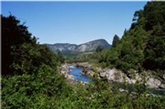
From Reefton to Murchison the road rises around 100 metres, not so steep that you would notice it and the
countryside to the junction at Inangahua is grand and open and generally light in traffic. From here the route
is taken up travelling through the Buller Gorge alongside a wild river running through a deep ravine of green
and blue pools and shingle basins. There is a
DOC camp
at Lyell, a grassed reserve dedicated to the scant remains of an old township. A few graves remain in
the bush, but little actually is left bar a few grey photographs in a display stand. While the setting is lovely
there is unfortunately no store and only a bare block of stone marks where the pub once was. What's more, the sandflies
here are ferocious!
Roughly 25 km further will bring you to Murchison, a small town with a bit of character with its old pubs and
interesting museum. There is a good sized store here and two campgrounds, one of which affords easy access to river-side swimming.
The pub also doubles as a backpackers. There is a laundrette (surprisingly) and cheap meals at the pub.
While 65 km does not sound too much for a day's cycle, the road from Murchison rises around 500 metres to St Arnaud.
Still, it is a pleasant and not overly steep route and the scenery is bush clad hills and fast rivers in deep
gorges. Around 35 km from Murchison you will need to turn right at Kawatiri Junction. Take plenty of water on this
section as there are no shops or garages. St Arnaud has a good sized store and a good quality backpackers and
Youth Hostel. There is a DOC camp just out of town.
St Arnaud is the principal departure point for those wishing to travel the
Rainbow Road to Hanmer
Springs. A wonderful isolated, gravel road that winds through valleys and alongside and through rivers and over
bluffs. This is a one to two day trip and a guaranteed memorable experience. Again, take some insect repellent for
midges.