This route is alpine country and climbs to 900 metres before dropping down to the long, flat plains toward
Christchurch. It is dazzlingly beautiful and covers a diverse terrain of mountains, valleys and lakes. Those of
you familiar with the alpine passes from Switzerland to Italy might note similarities. The turnoff is at Kumara
Junction almost midway between Greymouth (18 km) and Hokitika (22 km).
The day starts easily enough through Kumara (10 km from turnoff) and then climbs steadily, but not too steeply
through to Jacksons (46 km from turnoff, cabins, pub and great campground). From Otira (65 km from turnoff,
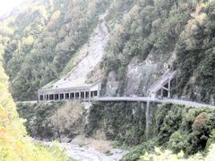
backpackers, pub, DOC campground at Kelly's Creek) the road rises steeply as you hit the pass proper. Arthur's
Pass (80 km from turnoff) is only a further 15 kilometres, but you will climb around 600 metres in that distance.
Head north out of Hokitika for about 9 km to Arahura. Once across the river take an immediate right into Old Christchurch Road.
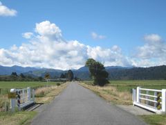
This quiet, country road follows the Arahura River gently up, mainly through rolling farm land with views up to the alps.
Sealed for the first 10 km, it continues along well graded gravel through the Okuku Scenic Reserve before descending to join
SH73 at about 30 km from Hokitika. For an easyish day stop over at Jacksons (pub, campground) a further 27 km along HW73
(just before the Lake Brunner turnoff).
Arthur's Pass is a township in the middle of a national park. If you are camping you can use the DOC camp or try
the local YHA which has a limited number of sites. It is a pretty spot and sports a number of short walks, day
hikes and longer tramps. Arthur's Pass is one of the great tramping areas of New Zealand.
When you decide to
leave, you might like to think it is all downhill to Christchurch. Alas no, the road dips beautifully for nearly
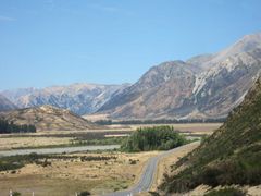
300 metres and nearly 40 kilometres and then rises steadily for 24 kilometres to Porter's Pass.
The four or five kilometres before the last pass are particularly steep and the road rises a further 400 metres.
From here (after you have taken in the magnificent view of the Canterbury Plains and the distant Pacific), it is
all downhill or flat for the next ninety odd kilometres to Christchurch.
Most cyclists use either Springfield, (83 km from Arthur's Pass, backpackers, camping in the Domain, store, pub) or
Darfield (106 km from Arthur's Pass, backpackers, store, pub) as a base before the last stretch to Christchurch.
Or you can skip Christchurch altogether and head north at Sheffield along the inland
Route 72.